This is about the Kvernevik hike, one of many hikes on the coast of Jæren, Norway. The hike on gravel is 3.6 km one way.
Orientation
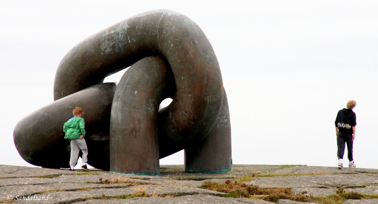
The rocks at the tip of Smiodden receive the rythmic pounding of the waves, while the trail winds in the hilly terrain of heather and grassland just inside. You don’t want to miss the “Broken Chain” memorial.
Kvernevik is located in the western part of Stavanger. Finding a place to park at the bay of Kvernevika can be a bit tricky, but look for opportunities across the road or at the parking lot at Håland Lake a few hundred metres towards Randaberg. There is also parking at the bridge on the other end of this hike, if you prefer to walk in the other direction. There are numerous bus stops along the Kvernevik circular road running parellell to the hiking trail, providing a number of opportunities for small and long hikes.
The combined biking and walking trail is fit for bikers, baby strollers and wheel chairs. My mapped hike is 3.6 km one way. The leg closest to the bridge may become a bit boring as you are forced to walk on the pavement along the ring road.
This article presents one of many hikes on the coast of Jæren, Norway. Get an overview and browse the rest here. Check out the map on this link.
What to see
The start of the hike
Kvernevik is outside the Jærstrendene Protected Landscape Area, but local jurisdiction has enforced protection of a large part of the described hike anyway. The protected area is not more than a couple of hundred metres away from the residencial areas in Kvernevik at the most, but it offers a more or less natural oasis in a populated city.
Starting in the Kvernevik end we encounter a couple of marinas along the narrow stretch of nature separating the rocky beach from the neighbouring houses. The largest marina is at Slettesviga, pictured below.
After this the trail takes us uphill almost to the ring road before entering the widest part at Smiodden. From here on we walk through the rare remaining coastal moorland in the city of Stavanger. It is particularly nice when the heather blooms.
What continues to fascinate visitors to Kvernevik is the variation offered by this hike. As the trail leads us over small and rolling hills further south we even find a couple of small woods, or groves.
The predominant feature remains that of the rocks. The waves hitting the rocks at Smiodden in particular are fascinating, especially on a windy day. Those waves have free access directly from the North Sea – and we have magnificent sea views all the way.
The middle section – a memorial
Out here we make a short sidetrip over to a strong and telling memorial visible from all sides, and even from Viste across the bay.
The monument “Broken Chain” is a memorial erected in memory of the Alexander L Kielland disaster in the North Sea where Kielland was operating as a residential platform. In March 1980 its structure broke down and the rig capsized. 123 people died in what remains the worst disaster in Norwegian oil history. Their names are inscribed on a board on the rock wall below the monument.
After the monument the trail continues past the small sandy beach at Kjøbenhavnerbukta (Literally Copenhagener Bay). At the next bay there is a small natural grotto (2x3m) created by the waves over thousands of years. It is only reachable on low tide. For those willing to look around there is also a Bronze Age burial mound to be found as well as a number of small bowls carved out in solid rock at roughly the same period in time, presumably for religious reasons.
The final stage
Shortly after this, at Hammaren, the trail ends and we walk the rest of this trip on pavement to Hafrsfjord Bridge, or return the same way we came.
The hike around Kvernevik Ring is also possible in winter, as illustrated in this video.
Further reading
This article presents one of many hikes on the coast of Jæren, Norway. Get an overview here. The hikes and corresponding articles are sorted in a north to south order. The adjacent hikes are:
North: Endrestø (Randaberg): A short and easy hike on a good trail between Viste beach and Kvernevik. To make it less easy, check out the rocky scenery at Endrestø.
South: Hafrsfjord (Stavanger): Hafrsfjord is one of the most significant fjords in the history of Norway. The walkable parts are on the eastern side (Stavanger) of the fjord. An exception is Sørnes in the municipality of Sola. It is worth visiting as it has a monument to the crucial battle of Hafrsfjord in the year 872.
There are hardly any other descriptions in English. The municipality of Stavanger offers two descriptions of trips in the area of Kvernevik partially along the trail I have described. They are both in Norwegian, with this one of Kvernevik Folkesti being the most informative. The other is alright as well. Both pdf documents have good maps.
The website Turanbefalinger has a fine description of this hike, in Norwegian.
Read more in my special article about Jæren’s geology, flora, fauna, history, people and art: Jæren – The coastline explained.
Les om strandturene på Jæren på “Sandalsand Norge”

