Intro
Countries
Photos
Blog
Facts
Overall impressions
The featured image is from New York with rows of skyscrapers in the background. The view is iconic: Millions have seen this scene or others from the Big Apple, in real life or on film. However, North America is a lot more than this.
This region covers Central and Northern America, including the Caribbean. The variations in this northern part of the Western Hemisphere are enormous. As a result, we have a very fascinating part of the world to travel in. Unfortunately, I have paid very few visits to North America. In fact I have only been to three of 23 independent countries: Canada, the United States and Cuba.
In addition, my visits were concentrated in time and space. One week in New York City and four days in the big cities in eastern Canada. The big exception was my road trip in Cuba. Sure, I did get many impressions from New York, but the Big Apple is far from average North America.
Moreover, most of my impressions of the United States and Canada are prejudiced. They are based on Americans I have met around the world, as well as reading about the countries, watching movies and so on. The rest of the Caribbean is a recurring element on my annual bucket lists.
As a matter of fact, I have always had this idea that I would need several months to properly experience North America. The problem is that I have not had the opportunity to venture on such a long journey for decades. Another reason is that the United States and Canada are countries that are easy to travel in, compared to many other parts of the world.
Consequently I have postponed my travels until I reach retirement. I still have a few years to go.
Countries
Antigua and Barbuda | Bahamas | Barbados | Belize | Canada | Costa Rica | Cuba | Dominica | Dominican Republic | El Salvador | Grenada | Guatemala | Haiti | Honduras | Jamaica | Mexico | Nicaragua | Panama | Saint Kitts and Nevis | Saint Lucia | Saint Vincent and the Grenadines | Trinidad and Tobago | USA
There are 23 independent countries in North America. I have only visited three. Click the links to access all posts from each country.
The rest are, in addition to Mexico in the north, situated in two sub-regions – continental Central America (seven countries) and the Caribbean island states (12).
There are also 27 dependencies and other areas. They range in size from Greenland to tiny islands like Sint Eustatius.
Here is a map of North America. Sandalsand has been to countries marked with a green colour, and not the yellow countries. (Source: Wikimedia Creative Commons Attribution-Share Alike 3.0 Unported (user Bosonic dressing))

Photo galleries
Open the box to view picture galleries from Sandalsand’s travels in this region.
Click to show or hide
Open a picture gallery in a new tab or window for a better view.


Posts from North America

Pictures from Canada
This collection of pictures from Canada is from a trip to the major cities in the eastern part of the country. Check out all Canada entries on this…

Ottawa, the capital of Canada
Ottawa, the capital of Canada attracts all visitors with splendid architecture, a beautiful river, world-class museums, a World Heritage Site, and…

World Heritage #1221 – Rideau Canal
The primary purpose of the Rideau Canal was to to keep the United States out of Canada. It was kind of a success. The UNESCO World Heritage List…

Quebec City is in Canada, but looks and sounds European
There’s an almost royal view of the mighty Saint Lawrence when you stand on the terrace in front of the Chateau Frontenac, in Quebec City. The…
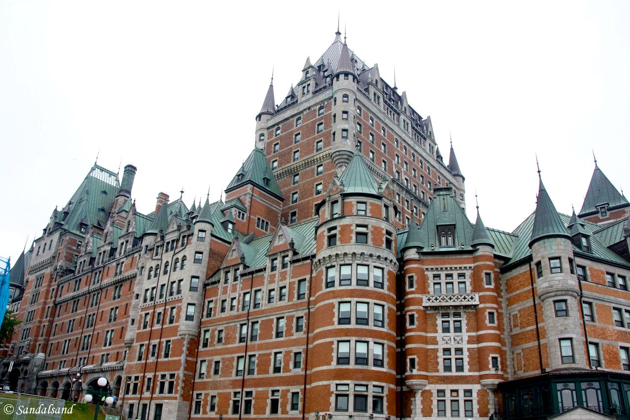
World Heritage #0300 – Old Québec
Old Québec City is so French, in architecture, language and traditions that you feel you have arrived in Europe. The UNESCO World Heritage List…

The city of Montreal is an amalgamation of all senses
Combining colonial architectural heritage with modern high-rises is not always easy. Montreal succeeds in offering visitors a lot of sights and…

Pictures from USA
This is Sandalsand’s collection of pictures from the United States (USA). They are all from a visit to New York. Check out all United States…

VIDEO – USA – New York’s High Line
This is a video from the High Line. On a sunny morning we had a great walk on Manhattan, parallel to the Hudson River. Join us for this walk (on…

VIDEO – USA – Central Park
A walk in Central Park is good meditation and can also be good exercise. There is much to see and enjoy, like the impressions in this video from…

VIDEO – USA – Brooklyn Bridge
This is a short video from a great walk across the Brooklyn Bridge, in the direction of Manhattan, New York. The walk across the bridge was part of…

VIDEO – USA – The Statue of Liberty
This is short video from a ride with the Statue Cruises ferry to Liberty Island, a walk around and up inside the Statue of Liberty. The statue is a…

Harlem, New York
What a pleasant surprise. Harlem was once a ghetto, yet with historical monuments, profound religious expressions and a jazzy atmosphere. …

Midtown Manhattan
Midtown Manhattan is south of Central Park and one of the island’s skyscraper areas. Join me for a walk around Midtown. …

The High Line, Greenwich Village and Flatiron – New York
It was a lovely Saturday morning in late April when we started on a walk through some of the quieter districts of Manhattan, starting with the High…

Liberty Island, Ellis Island and the Financial District of New York
We are going to Liberty Island, Ellis Island and the Financial District of New York. This is a full day in New York, filled with captivating things…
Traveling in Europe made me understand that America has an island mentality: No one exists except us. There’s a whole other world out there, but most Americans – all they know is America, the marketing plan.
A fact sheet
The first humans reached North America during the last glacial period. They crossed the Bering land bridge approximately 40,000 to 17,000 years ago. This is Wikipedia’s introduction to this region.
Map and numbers
")
- Area: 24,709,000 km2
- Population: 579,024,000 (2016)
- Population density: 22.9/km2
- Nominal GDP: $21.2 trillion (2016)
- PPP GDP: $24.4 trillion (2016)
- Per capita GDP: $41,830 (2016)
- Countries: 23 sovereign states
- Dependencies: 23 non-sovereign territories
Geography
North America is a continent entirely within the Northern Hemisphere and almost all within the Western Hemisphere. Some considers it to be the northern subcontinent of the Americas. It borders to the north the Arctic Ocean, to the east the Atlantic Ocean, to the west and south the Pacific Ocean, and to the southeast South America and the Caribbean Sea.
North America covers an area of about 24,709,000 square kilometers (9,540,000 square miles), about 16.5% of the earth’s land area and about 4.8% of its total surface. This is the third largest continent by area, after Asia and Africa, and the fourth by population after Asia, Africa, and Europe.
In 2013, its population was estimated at nearly 565 million people in 23 independent states. Altogether, this is about 7.5% of the world’s population, if nearby islands (most notably the Caribbean) are included.
History
Its first human populations reached North America during the last glacial period, via crossing the Bering land bridge approximately 40,000 to 17,000 years ago. The so-called Paleo-Indian period lasted until about 10,000 years ago (the beginning of the Archaic or Meso-Indian period).
The Classic stage spans roughly the 6th to 13th centuries. What is called the Pre-Columbian era ended in 1492, and the transatlantic migrations—the arrival of European settlers during the Age of Discovery and the Early Modern period. Present-day cultural and ethnic patterns reflect different kinds of interactions between European colonists, indigenous peoples, African slaves and their descendants.
European influences are strongest in the northern parts of the continent while indigenous and African influences are relatively stronger in the south. Because of the history of colonialism, most North Americans speak English, Spanish or French. Societies and states commonly reflect Western traditions.
Source
Wikipedia on a Creative Commons Attribution-ShareAlike License. Date: 2018-06-22.