
Discover Montenegro’s Durmitor National Park, a site of towering peaks, deep canyons, glacial lakes, and unspoiled alpine nature.
The UNESCO World Heritage List includes over a thousand properties. They have outstanding universal value and are all part of the world’s cultural and natural heritage.
Official facts
- Official title: Durmitor National Park
- Country: Montenegro
- Date of Inscription: 1980. Modifications to the boundaries in 2005
- Category: Natural
UNESCO’s World Heritage Centre’s short description of site no. 100:
This breathtaking national park was formed by glaciers and is traversed by rivers and underground streams. Along the Tara river canyon, which has the deepest gorges in Europe, the dense pine forests are interspersed with clear lakes and harbour a wide range of endemic flora.
Durmitor is a stunning limestone massif located in Northern Montenegro and belonging to the Dinaric Alps or Dinarides. It is also the name of Montenegro’s largest protected area, the Durmitor National Park, which constitutes the heart of a landscape shaped by glaciers, numerous rivers and underground streams of which are embedded in the much larger Tara River Basin Biosphere Reserve.
Some fifty peaks higher than 2,000 metres above sea level rise above plateaus, alpine meadows and forests, including Bobotov Peak (2,525 metres above sea level). Numerous glacial lakes, locally known as “mountain eyes”, cover the landscape.
Despite its many attractions, Durmitor is best known for the spectacular canyons of the Draga, Sušica, Komarnica and Tara Rivers, the latter stands out as Europe’s deepest gorge. Durmitor is a popular tourism destination, known for superb hiking, climbing, mountaineering and canoeing opportunities. The nearby town of Žabljak is Montenegro’s primary ski resort.
More about Durmitor
Durmitor National Park lies in the northern part of Montenegro, where rugged peaks, deep canyons, and alpine meadows create one of Europe’s most dramatic landscapes. The park centres around the Durmitor massif, carved by glaciers and intersected by rivers, including the Tara River, whose canyon is among the deepest in the world. With its crystal-clear lakes, dense pine forests, and high mountain plateaus, the area offers a remarkable variety of natural scenery.
The park supports rich biodiversity, with numerous endemic and rare species of plants and animals. It is also a favourite destination for hikers, climbers, and nature lovers. Trails lead to panoramic viewpoints and glacial lakes such as the famous Black Lake near Žabljak. Moreover, the Tara River is famous for white-water rafting, drawing visitors seeking both beauty and adrenaline.
My visit to the Durmitor National Park
Context and surroundings
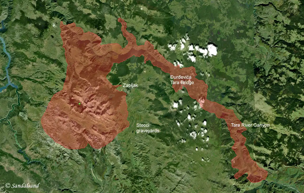
The map above is copied from UNESCO’s site and shows the outline of this heritage site. Sandalsand has added a few place names which will be explained in the following.
Basically the Durmitor national park, and the corresponding World heritage site, covers the Tara river canyon, which is the narrow tongue in the centre and right of this image.
Second, it spans the mountainous area with plains and other canyons in the large bulge to the left (west) on the map. That is where we find the famous scenic road which goes by the name of the Durmitor Ring. Read about it below.
Places to visit
The town of Žabljak is the centre in this region. This is where we find hotels, most private accommodations, restaurants and all other services to the local population and visitors alike. It is not a particularly interesting place, but a convenient location to base one’s exploration of the area from. I had found a place to stay here and spent a couple of nights.
As a keen observer of World heritage sites this area comes with (at least) a double opportunity. There are namely two locations just a short drive outside of Žabljak that are part of a UNESCO property by the name of Stećci Medieval Tombstones Graveyards. This is a serial property in several Balkan countries and includes 28 selected sites. Two of them are here, and I visited both. After all, they are quite close to one another.
On that side trip I also made my way into the Tara River Canyon to more specifically look up the Đurđevića Tara Bridge. This a a place for the adrenaline hunters, whether it is by zipline or rafting. I cared for neither, but thoroughly enjoyed the view from the bridge.
Here are a few images:

")
")


A road trip on the Durmitor Ring
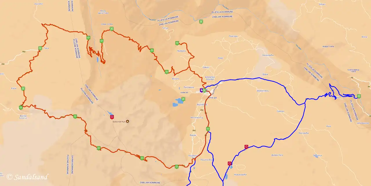
The image above is a only a static excerpt of Sandalsand’s own road map in the Balkans. However, find the dynamic map on this link, and zoom in on the details. I will explain some of the markers in the text below as well.
I had been on a round trip of the Balkans in the summer of 2025 and stayed a couple of nights in the Žabljak. The Durmitor Ring is a scenic road mostly inside the national park. The best, and in reality only starting point is Žabljak.
Now, and this is important, all road trippers should drive the Durmitor Ring in a counter-clockwise direction. The road is so narrow that it will be difficult to meet and pass other vehicles going in the opposite direction. I met some who had clearly not listened to this advice, and they were of great nuisance.
A few more tips:
- There are no petrol stations inside the Ring.
- The road is closed in winter and drivers should take care in the shoulder months. Best time of travel is May to October.
- Only medium sized camper vans or smaller vehicles are suitable for this road.
- There is an entrance fee for the park, payable in Žabljak, the Black Lake and at the bottom of the Sušica Canyon.
- Drive carefully. This road is at times very narrow, curvy, steep and demands your full concentration.
- The ring road is only 90 km, but you should allow 3-4 hours at least. Follow the Panoramic Road #2 road sign.
From Žabljak to the Sušica Canyon
Before you actually leave Žabljak head in the opposite direction to the Black Lake. It’s only five minutes by car, or half an hour walk from the town. Great view and for some, also great hikes in the area. The parking lots are within a few minutes of walking from the lake.
In the following I will mention some of the places marked on the map.
Ćurevac (detour): This is extra, if you have time. Some say it offers the best views of the Tara canyon, the deepest gorge in Europe. The park authorities recommend a hike to a hilltop for the best views.
Tara Canyon Viewpoint: Another spot to see the Tara canyon. Good addition or alternative to Ćurevac. This canyon is the deepest in Europe and second deepest in the world, after the Grand Canyon in the U.S. The highest altitude is 1,333 metres and the length is 78 kilometres, formed by the Tara canyon.


Next up is the Sušica Canyon. Before you descend into the canyon, you might want to have a look at the tiny village of Mala Crna Gora. It is home to 14 inhabitants. They are cut off from the rest of the country for the duration of the winter. At Vidikovac there is a great viewpoint of the Sušica Canyon before you descend on a steep and winding road. There are more viewpoints almost all the way down.
At the bottom of the Sušica Canyon it is possible to park and explore the valley on foot. The rest of us will have to steer our wheel up on the other side of the valley and to the next viewpoint, at Nedajno. Grab a coffee at the kiosk and admire the 15 kilometres long and 700 metres deep canyon.


From the Sušica Canyon and round the clock
Right up until now the road has been extremely shifting and turning, with lots of bends. There is also a lot of vegetation in terms of trees, meaning forests. The forested landscape continues to the next possible stop, at Trsa. This tiny settlements offers opportunities for a snack, hikes, and also horse riding. There is even accommodation available here.
Take a look at the strange looking monument to the victims of WW2.


After this we reach Pišče, another tiny village (20 people). Here they make sheep cheese. By now we have moved into a more open scenery, less forests and even wider vistas. Strange rock formations appear on the mountains and the road climbs high.
Coming up next are two huge photo frames, at Prutaš and at Sedlena Greda (Saddle of the Gods). These vast stretches of meadows and towering mountains are easily the most fascinating in the national park, in my opinion.
The road continues over the Sedlo Pass, the highest road pass in Montenegro with incredible views. After Sedlo, the road descends again before returning in the direction of Žabljak.


Read more
Consult the map for more details. Also, get hold of the official map of the Durmitor Ring. I used information on it to make my own.
Find more articles from Montenegro on Sandalsand.